Finding the right Freiburg im Breisgau tourist map makes the difference between wandering lost in the Altstadt's medieval streets and efficiently hitting the city's best spots. The good news: Freiburg offers some of Germany's most detailed and useful tourist maps, both digital and printed. The bad news: not all maps are created equal, and some widely available options will lead you astray.
We've tested every major tourist map option available in 2026, from the official city publications to third-party apps and hiking route guides. Here's what works, what doesn't, and where to get the maps that will actually help you navigate this Black Forest gateway city.
Official Freiburg Tourist Maps: Your Best Starting Point
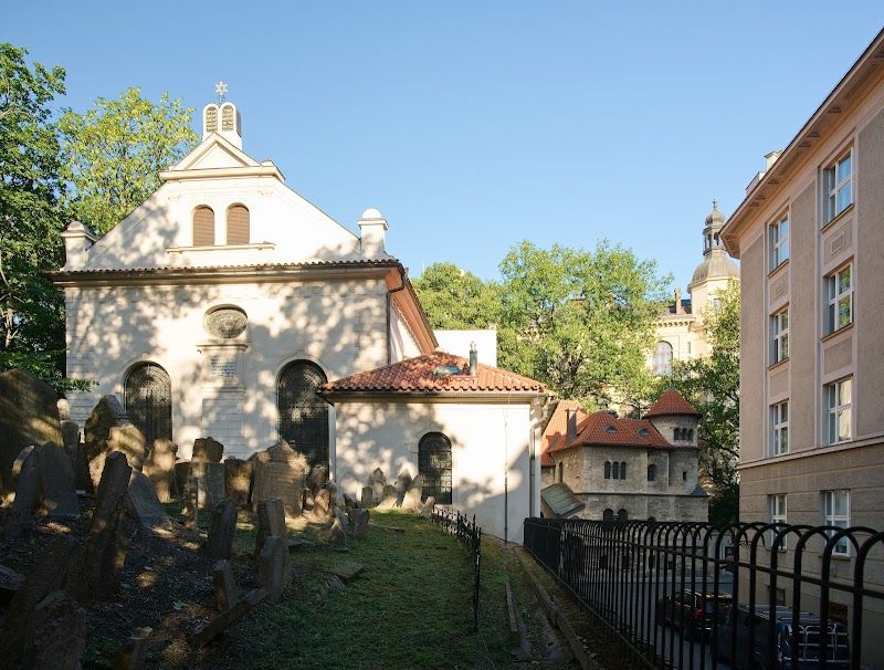
The Freiburg Tourism Office produces three primary maps that cover different visitor needs. The basic city center map covers the Altstadt core from Bertoldsbrunnen to the Munster, while the comprehensive city map extends south to Wiehre and west to the Hauptbahnhof. The hiking and outdoor map covers the immediate Black Forest slopes including the Schauinsland cable car route.
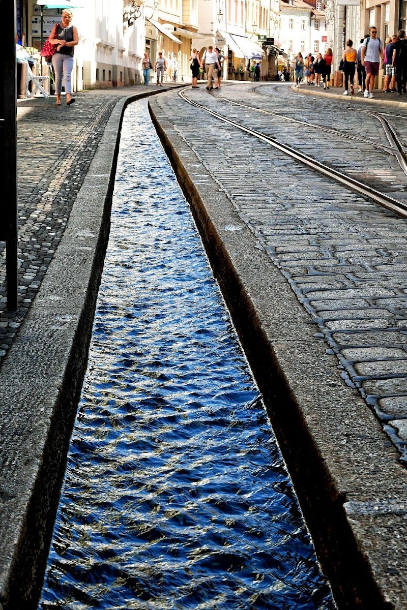
The standard city center tourist map remains the most practical choice for first-time visitors. It clearly marks the Bachle water channels that run through the cobblestone streets, shows the exact location of the Freiburg Munster and its 116-meter tower climb (EUR 5), and includes walking times between major attractions. The scale works perfectly for the compact Altstadt - you can see everything from the Martinstor gate to the Historisches Kaufhaus on one double-sided sheet.
The comprehensive city map proves essential if you're staying outside the old town. It includes detailed tram and bus route information (crucial since day passes cost EUR 6.60), marks the student quarter around Stuhlinger, and shows the path up Schlossberg hill for the city's best viewpoint. The map also includes the eco-district Vauban with its famous rotating Heliotrop solar house.
Where to Get Official Maps for Free
The Freiburg Tourist Information office at Rathausplatz 2-4 stocks all official maps and opens Monday-Friday 8 AM to 6 PM, Saturday 9:30 AM to 5 PM, Sunday 10:30 AM to 3:30 PM. This location sits directly on Munsterplatz, making it impossible to miss if you're visiting the cathedral. The staff speaks excellent English and can mark specific routes on your map.
Hotel reception desks throughout the city stock the basic tourist map, though availability varies by establishment. Mid-range hotels like those along Eisenbahnstrasse typically have both German and English versions, while budget accommodations may only carry German-language maps.
Freiburg Hauptbahnhof information desk keeps tourist maps behind the counter (ask specifically - they're not displayed). The desk operates daily 6 AM to 10 PM and proves convenient if you're arriving by train from other German cities.
Digital Maps and Offline Downloads
The official Freiburg Tourism app includes downloadable offline maps that work without cellular data. The app covers the same ground as the printed versions but adds GPS positioning and audio guides for major attractions. The offline functionality proves crucial in the Black Forest hills where cellular coverage can be spotty.
The digital maps include real-time public transport information integrated with the VAG (Freiburg's transport authority) system. You can see exactly when the next tram arrives at Bertoldsbrunnen or track bus connections to reach Mundenhof animal park in the western suburbs. The transport integration alone justifies downloading the app.
Google Maps offline download covers Freiburg adequately but misses crucial tourist-specific information. While Google shows streets and basic points of interest, it doesn't mark the Bachle channels (essential for navigation since they run one-way through pedestrian areas), fails to indicate which Altstadt streets are pedestrian-only, and provides no information about opening hours or admission prices.
Specialized Route Maps Worth Getting
The Schauinsland hiking map becomes essential if you're planning to explore beyond the cable car station. Available at the Schauinslandbahn valley station (cable car costs EUR 13-21 return), this detailed topographic map shows marked hiking trails, mountain huts, and connections to longer Black Forest routes. The map indicates difficulty levels and estimated walking times between points.
VAG transport network maps are distributed free at any tram stop and prove invaluable for families staying outside the city center. The maps clearly show zone boundaries (important since single tickets cost EUR 2.80 within zone 100), connection points, and late-night service routes. If you're visiting Steinwasen Park or taking the regional train toward the Black Forest, these zone maps prevent expensive ticket mistakes.
Best Third-Party Map Options
Kompass hiking maps provide the most detailed topographic coverage of the greater Freiburg region. The 1:25,000 scale "Freiburg im Breisgau - Schauinsland" edition shows every hiking trail, mountain bike route, and forest path within a 20-kilometer radius of the city. Available at the Thalia bookstore on Kaiser-Joseph-Strasse for around EUR 12, these maps prove essential for serious Black Forest exploration.
City-Data street atlases offer building-level detail that tourist maps skip. While overkill for casual sightseeing, these EUR 8-15 atlases help if you're apartment-hunting, looking for specific businesses, or need to navigate residential areas like the quieter parts of Wiehre. The Falk Stadtplan edition includes a comprehensive street index.
Navigation Tips for Freiburg's Unique Layout
The Bachle water channels provide the best navigation reference points in the Altstadt. These narrow streams run in predictable patterns: the main channel flows north-south along Gerberau, while smaller branches flow east-west toward the Dreisam river. Follow the Bachle flow to reach the river (and Seepark), or walk against the current to reach higher elevations toward Schlossberg.
Street numbers in Freiburg run counterintuitively - odd and even numbers don't always alternate sides, particularly in the medieval Altstadt where buildings were numbered chronologically rather than by position. Tourist maps typically mark major buildings and attractions rather than relying on street addresses, which proves much more practical for navigation.
The Altstadt's pedestrian zones change throughout the day. Some streets allow delivery vehicles until 11 AM, while others remain car-free except for residents. Tourist maps mark these zones, but timing matters - what looks like a normal street at 10 AM becomes pedestrian-only by afternoon.
Practical Route Planning With Maps
Old Town Walking Circuit
The standard tourist walking route covers 2.5 kilometers and takes 2-3 hours with stops. Start at Bertoldsbrunnen (the city center intersection), walk east to the Munster via Salzstrasse, climb the cathedral tower (EUR 5 - budget 45 minutes for the queue and climb), then follow the Bachle channels south to Oberlinden square. Return via the shopping streets around Kaiser-Joseph-Strasse.
The extended circuit adds Schlossberg hill for panoramic city views. From the Munster, walk east up Schlossbergring (marked clearly on all tourist maps) to reach the tower ruins and viewpoint. The climb takes 20 minutes and rewards you with views across the Rhine plain to the French Vosges mountains. Descent options include the funicular-style Schlossbergbahn or walking paths marked on detailed maps.
Family-Friendly Routes
Families with young children should prioritize flat routes that follow the Bachle channels. The water features keep kids engaged while parents navigate, and the channels lead directly to major attractions like the Munster and Historisches Kaufhaus. Our family guide includes specific routes that avoid steep hills and lengthy walks between attractions.
The Seepark and Mundenhof combination requires good transport planning. Both locations sit west of the city center and connect via bus route 11. Tourist maps show the connections, but double-check current timetables since weekend service runs less frequently. The combination makes an excellent half-day outing for families seeking green spaces and animals.
What to Avoid in Tourist Maps
Generic "Black Forest" maps often include Freiburg as a tiny inset with insufficient detail for actual city navigation. These regional maps work for understanding Freiburg's position relative to other Black Forest towns but provide useless information for walking around the Altstadt or finding specific restaurants and attractions.
Outdated maps remain in circulation at some hotels and hostels. Construction around the Hauptbahnhof and new tram extensions mean maps older than 2024 may show incorrect transport routes or closed streets. Always check the publication date, especially for public transport information.
Restaurant and shopping maps distributed by commercial establishments focus on paying advertisers rather than genuine quality. These "insider" maps typically omit excellent local spots like Hausbrauerei Feierling while prominently featuring mediocre tourist restaurants that pay for placement.
Budget Considerations and Free Alternatives
All essential tourist navigation can be accomplished with free maps available at the tourism office and major hotels. Paid map options only add value if you're planning serious hiking, need building-level detail for specific purposes, or want premium paper quality for extended outdoor use.
The KONUS guest card (included with overnight accommodation throughout the Black Forest region) provides free public transport throughout the area, making transport zone maps less critical for route planning. However, you still need basic city maps to understand where tram and bus stops connect to walking routes.
Smartphone battery backup becomes crucial when relying on digital maps. Freiburg's compact size means a printed backup map weighs almost nothing and provides insurance against dead batteries or poor cellular service in the surrounding hills.
Seasonal Map Updates and Special Considerations
Summer hiking maps include additional seasonal trail information not shown on year-round versions. The Schauinsland area opens additional high-altitude trails from May through October, while some forest paths close during hunting season (November-January). Current maps reflect these seasonal restrictions.
Christmas market season (late November through December 23) transforms the Altstadt layout significantly. Special event maps show the location of market stalls, modified traffic patterns, and temporary attractions like the Christmas pyramid on Munsterplatz. Regular tourist maps become less useful during this period.
Festival and event periods can render standard maps partially obsolete. Freiburg's summer music festivals, university celebrations, and outdoor markets modify normal walking routes and street access. Check with tourist information for current-week map updates during major events.
The right Freiburg im Breisgau tourist map transforms your visit from a series of wrong turns into an efficient exploration of one of Germany's most walkable cities. Start with the free official city center map from the tourism office, add the smartphone app for real-time transport information, and consider specialized hiking maps only if you're planning serious Black Forest exploration. With these tools, you'll navigate Freiburg's medieval streets and modern eco-districts like a local.