The Alsace wine trail map reveals a deceptively simple truth: the Route des Vins d'Alsace runs 170 kilometers from Marlenheim (north of Strasbourg) to Thann (south of Colmar), but the real navigation challenge isn't following the main road. It's choosing which villages deserve your time and which detours lead to the best cellars.
Here's the reality of wine trail navigation in Alsace: the main D422 road carries the official route markers, but the postcard villages that make this journey worthwhile sit on side streets, up hillsides, and behind vineyard walls. Your Alsace wine trail map needs to account for these diversions, parking restrictions, and the fact that GPS often routes you around historic village centers rather than through them.
Understanding the Alsace Wine Trail Map System
The Route des Vins uses a combination of official signage and regional trail markers that can confuse first-time visitors. Brown signs with grape clusters mark the main route, but these signs prioritize traffic flow over tourist stops. They'll keep you on major roads but won't direct you to the circular streets of Eguisheim or the ramparts walk in Riquewihr.
Wine trail distances between major villages break down as follows:
| Starting Point | Destination | Distance | Driving Time | Notes |
|---|---|---|---|---|
| Marlenheim | Obernai | 25 km | 25 minutes | Northern route start |
| Obernai | Sélestat | 32 km | 30 minutes | TER train connection point |
| Sélestat | Ribeauvillé | 12 km | 15 minutes | Castle views begin |
| Ribeauvillé | Riquewihr | 5 km | 8 minutes | Tourist concentration peak |
| Riquewihr | Kaysersberg | 8 km | 12 minutes | Via Sigolsheim |
| Kaysersberg | Colmar | 12 km | 18 minutes | Regional hub |
| Colmar | Eguisheim | 7 km | 10 minutes | France's favorite village |
| Eguisheim | Rouffach | 18 km | 20 minutes | Southern section begins |
| Rouffach | Thann | 25 km | 30 minutes | Route terminus |
These distances represent the direct route between village centers. Add 20-30% more time if you're stopping for photos, navigating village parking, or following wine trail detours through vineyard roads.
Trail Markers and Navigation Waypoints
Alsace uses three types of wine trail navigation markers that overlap and sometimes contradict each other:
Brown tourism signs mark the official Route des Vins and include distance indicators to major towns. These signs assume you're driving and prioritize traffic flow. Green hiking trail blazes mark the Sentier Viticole (vineyard footpath) that runs parallel to the road route but takes you directly through vine rows. Local village directional signs point to individual cellars, cooperatives, and tasting rooms within each wine village.
The key navigation waypoint most visitors miss: Château du Haut-Koenigsbourg sits 8 kilometers uphill from Sélestat and provides the best overview of the entire wine trail route. From the castle's viewing platform, you can see the ribbon of vineyards stretching from the Vosges foothills to the Rhine plain. This perspective helps you understand the wine trail geography that no ground-level map conveys.
Northern Route Navigation: Obernai to Ribeauvillé
The northern section of your Alsace wine trail map covers the stretch from Obernai to Ribeauvillé, where the route transitions from farming villages to tourist destinations. This 44-kilometer section includes the steepest vineyard climbs and the most confusing village access roads.
Obernai serves as the practical starting point for most wine trail navigation. The town sits directly on the TER train line (EUR 7.5-12 from Strasbourg), has reliable parking outside the ramparts (EUR 4-8 per day), and provides your last chance to stock up on supplies before entering the smaller wine villages. Obernai Market Square and Ramparts offers free exploration of 14th-century walls that encircle a perfectly preserved Alsatian town square.
The trail markers between Obernai and Barr lead through actual working vineyards rather than tourist zones. Wine trail distances here require more time because you're driving through narrow vineyard service roads with frequent stops for tractors and harvest equipment (especially September-October). The payoff: you'll stop at family domains like Domaine Klur in Katzenthal where tastings cost EUR 8-15 and you're often poured wine by the person who grew the grapes.
Navigation waypoint: Mont Sainte-Odile Monastery requires a 12-kilometer detour up the Vosges mountainside from Obernai. The monastery itself offers free entry and panoramic views, but the real attraction for wine trail navigation is the Mur Païen (Pagan Wall), a mysterious pre-Roman stone wall that runs for 10 kilometers along the ridge. The hiking trail provides the best vantage points for photographing the vineyard patterns below and understanding how the wine trail route follows the geological transition between mountain and plain.
Between Barr and Ribeauvillé, your wine trail map needs to account for the three-castle detour that leads to Les Trois Châteaux de Ribeauvillé. These 13th-century ruins require a 45-minute hike from Ribeauvillé town center, but the trail provides the clearest view of how the Route des Vins follows the geological fault line between the Vosges granite and the Rhine plain sediments that create Alsace's unique wine terroir.
Village Access and Parking Navigation
Most wine villages restrict car access to their historic centers, creating navigation challenges that standard GPS doesn't solve. Ribeauvillé closes its main street (Grand Rue) to traffic from 10h00-18h00 during peak season (May-October). Park at the Parking des Remparts (EUR 6 per day) and walk 400 meters to the village center.
Riquewihr completely bans cars from the medieval walls. The Parking de la Piscine (EUR 8 per day, free November-March) sits 300 meters from the Riquewihr Main Street. Every tour bus stops here because the main street represents the platonic ideal of an Alsatian wine village - half-timbered houses from the 1400s housing active wine shops, restaurants, and tasting rooms.
Central Route: The Tourist Corridor
The central section of your Alsace wine trail map runs from Riquewihr south through Kaysersberg to Colmar, covering the 20 kilometers that appear in every Alsace travel photograph. This section has the heaviest tourist traffic, the most expensive parking, and the highest concentration of excellent wine cellars.
Wine trail navigation through Riquewihr follows a single main street (Rue du Général de Gaulle) that survived World War II intact. Every building on this street dates to the 1400s-1600s and now houses wine shops, tasting rooms, or restaurants. The navigation challenge: the street runs only 400 meters end-to-end, creating bottlenecks when tour groups arrive.
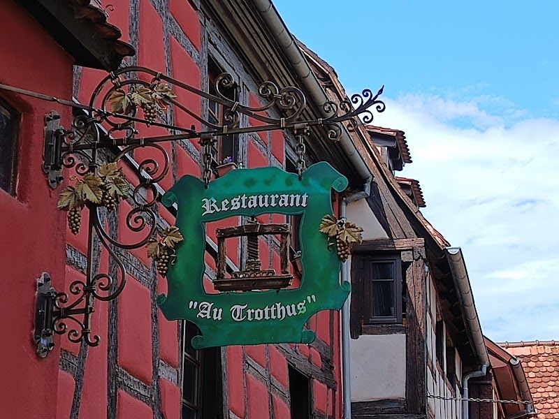
Strategic timing for Riquewihr navigation: arrive before 10h00 or after 16h00 to avoid tour bus crowds. The village empties after 17h00, when shops close and day-trippers depart, but several wine cellars offer evening tastings by appointment. Au Trotthus serves dinner until 21h30 and sources ingredients from the kitchen garden behind the restaurant.
Kaysersberg sits 8 kilometers south via the D28 road that passes through Sigolsheim, where American and German cemeteries mark the 1944-1945 battles for the Colmar Pocket. Your wine trail map should include this detour because Sigolsheim produces some of Alsace's most distinctive Pinot Noir, the red wine that most visitors don't realize exists in this region.
Kaysersberg offers more substantial navigation rewards than the typical wine village. Albert Schweitzer was born here, and his museum provides context for understanding how Alsatian culture bridges French and German influences. More practically, Kaysersberg has the best bakeries on the wine trail. Boulangerie Laurent on Rue du Général de Gaulle sells authentic kougelhopf (EUR 3.5-5 per slice) that pairs perfectly with Munster cheese for vineyard picnics.
The Kaysersberg Castle Ruins require a 20-minute climb from the village center but provide panoramic views of the Weiss Valley and the vineyard slopes that produce Kaysersberg Grand Cru wines. The trail markers here connect to longer hiking routes that follow vineyard paths between villages - an alternative to road navigation when traffic becomes frustrating.
Wine Cellar Navigation and Tasting Logistics
Professional wine trail navigation requires understanding cellar schedules and booking requirements. The most acclaimed domains - Domaine Famille Hugel in Riquewihr, Domaine Marcel Deiss in Bergheim, Domaine Trimbach in Ribeauvillé - require advance booking for tastings (EUR 18-35) and often close for lunch from 12h00-14h00.
Cooperative cellars like the Cave de Turckheim and Cave d'Eguisheim accept walk-in visitors and offer entry-level tastings (EUR 8-18) that include 5-7 wines. These cooperatives represent multiple small growers and provide better value for understanding regional wine styles than individual domains.
Your wine trail map should mark the distinction between négociant houses (who buy grapes and blend wines from multiple sources) and estate producers (who grow, make, and bottle their own wines). Estate producers offer more intimate tastings and often include vineyard walks, but négociant houses like Hugel & Fils have more extensive cellars and can pour older vintages.
Southern Route: Colmar to Thann
The southern portion of your Alsace wine trail map covers the 45 kilometers from Colmar to Thann, where the route transitions from tourism to serious winemaking. This section has fewer postcard villages but more opportunities for authentic cellar visits and vineyard hiking.
Colmar serves as the wine trail's logistical hub rather than a destination village. The city provides train connections (TER to Strasbourg EUR 7-13, advance booking), car rental pickup (EUR 45-75 per day), and the Unterlinden Museum (EUR 13-15) that houses Grünewald's Issenheim Altarpiece - worth a half-day detour even from focused wine trail navigation.
Eguisheim sits 7 kilometers south of Colmar and represents the wine trail's most unique navigation challenge. The village follows a circular medieval street plan - two concentric rings around a central square - that creates a natural walking tour. Eguisheim Circular Village offers free exploration, but the real attraction lies in understanding how this layout reflects medieval wine-trading logistics.
The outer ring housed merchants and coopers, the inner ring housed winemakers, and the central square served as the trading floor. This layout still functions today: Domaine Emile Beyer operates from a 16th-century merchant house on the outer ring, while smaller family domains occupy the inner ring buildings. Auberge du Rempart serves dinner in a former cooper's workshop with original oak-barrel aging caves below the dining room.
Vineyard Trail Hiking Routes
South of Eguisheim, your wine trail map should include the Sentier Viticole Grand Cru that connects the villages of Husseren-les-Châteaux, Voegtlinshoffen, and Pfaffenheim via vineyard footpaths. This 12-kilometer hiking route takes 3-4 hours and passes through three Grand Cru vineyard sites where you can taste the soil differences that create distinct wine styles.
Navigation markers for vineyard hiking use yellow blazes painted on stone posts every 100-200 meters. The trail includes interpretive panels (in French and German, some English) that explain how slope angle, soil composition, and sun exposure affect wine quality. This hiking section provides practical education that complements cellar tastings.
The Ballons des Vosges Regional Nature Park begins at Thann and offers more ambitious hiking routes that connect wine villages to mountain peaks. The Vieil Armand battlefield site provides historical context for understanding how World War I and World War II shaped modern Alsatian wine culture - the region changed nationality four times between 1871 and 1945, creating the unique Franco-German hybrid culture that defines Alsace today.
Transportation and Logistics for Wine Trail Navigation
Car rental provides the most flexible wine trail navigation but creates the obvious problem of drinking and driving. TER trains connect major towns (Strasbourg-Colmar EUR 7-13, Strasbourg-Sélestat EUR 7.5-12) but don't reach the postcard villages that justify the trip. The Alsa Plus 24h Solo pass (EUR 19-23) provides unlimited TER trains and regional buses, but bus service to wine villages runs infrequently and stops early.
Professional wine tours (EUR 75-130 per person) solve the transportation problem by providing pickup in Strasbourg or Colmar, visits to 3-4 wineries, lunch, and return transport. Operators like Ophorus and Alsace Tours know which domains require booking and can arrange access to cellars that don't accept walk-in visitors.
Bike rental (EUR 18-30 per day for e-bikes) works for the flat sections between villages but becomes challenging for vineyard hill climbs and castle detours. The EuroVelo 5 cycling route parallels the wine trail and includes dedicated bike paths, but these paths bypass village centers where the best cellars operate.
Strategic base location for wine trail navigation: choose Colmar for train access and restaurant options, choose Riquewihr or Eguisheim for medieval atmosphere and walking access to cellars, choose Kaysersberg for hiking trail connections and authentic village life. Avoid Strasbourg as a base - it's 45 minutes from the main wine villages and offers no advantages except airport connections.
Your wine trail map planning should account for village closing times - most wine shops and tasting rooms close by 18h00, restaurants serve dinner 19h00-21h30, and village streets empty after 20h00. The exception: cooperative cellars often stay open until 19h00 and some domains offer evening tastings by appointment.
Seasonal navigation considerations: May-June and September offer the best weather and fewer crowds, July-August brings maximum tourist traffic and parking challenges, October provides harvest season atmosphere but unpredictable weather, November-March drastically reduces opening hours but eliminates crowds. Christmas markets transform the wine trail from December 1-24, with free market entry but accommodation booking essential months in advance.
The Alsace wine trail map reveals its secrets gradually. Start with the obvious villages - Riquewihr, Eguisheim, Kaysersberg - then use local knowledge from cellars and restaurants to discover the producers and hiking trails that create authentic experiences beyond the tour bus circuit.